Signed in as:
filler@godaddy.com

Visualizing complex urban systems by integrating spatial, social, digital, and infrastructural data to reveal patterns, relationships, and opportunities for strategic planning..
Structuring data, workflows, and system components into clear, scalable frameworks that support seamless interaction, real-time operations, and intelligent decision-making.
Designing smart wayfinding and mobility pathways that enhance accessibility, improve user flow, and connect people intuitively across the urban landscape.
Creating the digital and physical touchpoints where users interact with city systems—combining accessibility, usability, and responsive design for meaningful engagement.
Shaping the human-centered journey across services, platforms, and city spaces to ensure inclusivity, comfort, and seamless interaction with urban technologies.
Producing spatial media, visualizations, and immersive storytelling tools that communicate urban intelligence and support public engagement.

- Smart cities
- Pervasive computing applications for urban planning and design
- Urban mobility and geo-localization
- Multi-source urban information integration
- Real-time urban information processing
- City-related knowledge infrastructure and computational models
- Applications for urban sensing and mining
- Analysis of social networks in urban space - context-aware systems
- Intelligent transportation system
- Urban application demos and visualizations
- Wireless sensor networks, mobile devices, & social network sensing
A large-scale redevelopment transforming 25 acres into a transit-oriented, mixed-use district anchored by pedestrian streets, residential neighborhoods, entertainment areas, and improved transportation links.
The project enhances urban livability and economic vitality by leveraging major rail connections, including the NJ PATH Harrison Station and the NJ Transit East Coast Corridor, positioning the area as a vibrant commuter village.
The streetscape design delivers full accessibility and intelligent urban-media features, integrating smart wayfinding and digital components to create an optimized, seamless experience for residents.
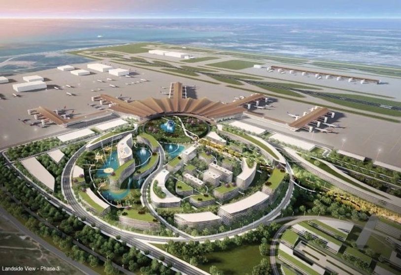
A transformative aviation-driven development model centered around U-Tapao Airport, expanding regional economic potential through airport-linked commercial zones, logistics clusters, and mixed-use hubs. The plan creates a long-term framework for aviation growth, innovation, and tourism, positioning U-Tapao as an integrated smart gateway within the EEC’s future mobility ecosystem.

Illustration of the complete system architecture created and operated by SIAC (Securities Industry Automation Corporation) for the New York Stock Exchange. The visualization maps the full ecosystem —including servers, networks, gateways, messaging layers, monitoring systems, and real-time operational states—to show how millions of financial transactions are processed, validated, and distributed each second. The system OS was developed as a special project within Prof. C. Kirwan’s Information Architecture course at Parsons School of Design, in the Master’s Program in Design and Technology.

This study maps the complex movement patterns of Beijing’s workforce across subway, bus, car, and bicycle networks, visualizing how different modes intersect and negotiate shared urban space. By analyzing flows, accessibility, and behavioral patterns, the framework reveals opportunities to optimize multimodal mobility, reduce congestion, and improve the daily commuting experience for millions of residents.

A vision for a next-generation smart community park in Riyadh, integrating green corridors with active mobility, play, education and recreation spaces, and community amenities. Digital elements such as kiosks, wayfinding, and smart furniture enhance user experience and connect the park to the wider smart-city ecosystem.


Visualization presenting a comprehensive, city-scale analysis of Buffalo, integrating stakeholders, policy frameworks, digital portals, and citizen engagement. By mapping a full spectrum of urban socio-economic and physical factors—including infrastructure, schools, mobility networks, and community facilities—the framework enables evidence-based planning and allows the city to evaluate long-term development scenarios with clarity, precision, and real community relevance.

Buffalo at multiple scales—regional, citywide, district, and parcel-level—to reveal spatial patterns of opportunity and need. Using C. Kirwan’s Urban Health Metrics criteria, the study integrates demographics, land use, urban mobility, environmental quality, and socio-economic factors to guide strategic site selection. This data-driven approach ensures that new educational and municipal investments align with community health, equity, and long-term urban resilience.

A 300-acre strategic masterplan connecting airport infrastructure, commercial development, and media/branding to reposition Newark as a future mobility and economic hub.
The plan enhances connectivity, logistics capacity, and long-term economic positioning around Newark International Airport and the Port of New York

A $20B, 500-acre next-generation smart city district integrating innovation hubs, walkable commercial centers, green mobility networks, and advanced infrastructure. Designed as Utah’s flagship smart community, the project creates a long-term model for sustainable, tech-enabled urban growth in the Intermountain West.

A visionary 100-mile regional masterplan linking innovation districts, advanced mobility networks, logistics zones, and mixed-use population centers. The project positions Utah as a leading U.S. smart-mobility corridor by combining planning, digital infrastructure, and long-range economic strategy.

Urban Media project to develop an interactive public installation and event in Beijing’s 798 Art District utilizing mobile media and broadband telemedia applications to frame a trans-cultural dialogue between China and the US.
The project was a collaboration between Tsinghua University and Parsons The New School For Design and the Yuanfen New Media Gallery in Beijing’s 798 Art District.
A city-wide communication framework integrating interactive maps, digital signage, and coordinated media channels to position Newark as a connected, information-rich urban interface.
A network of interactive smart hubs designed to enhance mobility, wayfinding, and civic identity through real-time digital content and immersive urban media elements.

Collaboration between Tsinghua University (Prof. Fu), Parsons School of Design (Prof. C. Kirwan), and Ars Electronica in Linz, Austria, this project served as experimental research in applied technology for museums and interactive public spaces. It demonstrates how digital media and urban information can merge to create engaging educational and experiential interfaces.
This project developed an interactive media interface, screens and smart table map that allows users to explore the layered evolution of Beijing—from ancient history to contemporary urban systems. The platform integrates cultural sites, historical maps, and mobility networks into an immersive environment for intuitive spatial navigation.

Projec[tions] – New York City Digital Interface Spring/Summer 1996. Research and Development of new technologies for the convergence of touch sensor interface with emerging broadband / broadcast media. The first prototype was a physical immersive Installation and interactive map interface of NYC presented at the Emerging Technologies Expo at SIGGRAPH96 in New Orleans.
Multiple Identities – Digital Interface (Spring/Summer 1997). Research and development of new technologies for an interactive map of New York City built around eight unique user types derived from Howard Gardner’s theory of Multiple Intelligences. The installation and interactive map interface were presented at the Emerging Technologies Expo at SIGGRAPH ’97 in Los Angeles.